Publications

Announcement: AGIT 2017
The annual trade fair and conference for applied geoinformation (AGIT) will take place again this year from 4th to 6th July 2017. This largest Austrian conference for geoinformation will once again include a separate area for open source projects.
OpenStreetMap Austria will try to organise a stand again this year with the help of the German FOSSGIS association, where any OSM mapper can provide information about OpenStreetMap or present their OSM-relevant project.
OSM Wochennotiz Nr. 357
The new OSM Weekly Notes with the number 357 from our German colleagues is here.
At http://blog.openstreetmap.de/blog/2017/05/wochennotiz-nr-357 you will find a compilation of the latest information from the OpenStreetMap universe from the last week.

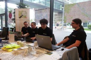
Linuxwochen 2107
From 04.05.2017 to 06.05.2017, Linuxwochen was held in Vienna again this year. On Friday, 5 May, OpenStreetMap was also represented with a stand. Although there were no special OpenStreetMap lectures, this did not mean that there was no interest in OpenStreetMap.
The stand was well attended throughout and the Free Software Foundation Europe (FSFE), which was also present, took a few packs of OpenStreetMap flyers with them so that they could distribute them themselves if needed. Furthermore, two of the OSM mugs were sold.
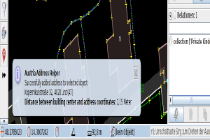
Austrian Address Helper
Thomas Konrad has published his plugin ‘Austrian Address Helper’ for the Java OpenStreetMap Editor (JOSM). This allows address data from the database of the Federal Office of Metrology and Surveying to be transferred to OpenStreetMap at the click of a mouse.
-> His original mailing list post can be found here.
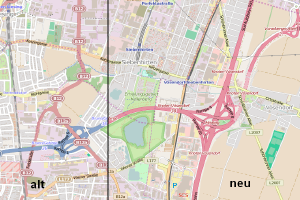
New map style at OpenStreetMap.org
A new map style was introduced at [osm.org](https://www.openstreetmap.org/ ‘Routing on osm.org’) at the end of October 2015: the motorways are now red, no longer blue!
[OSM Blog article](https://blog.openstreetmap.org/2015/10/30/openstreetmap-org-map-changing/ ‘osm.org map changing’) (in English) about this.
Linuxwochen 2015
At the [Linuxwochen Wien](http://www.linuxwochen.at/Wien ‘Linuxwochen 2015’) from 7 to 9 May 2015 [FH Technikum Wien, 1200 Vienna, Höchstädtplatz 6](http://www.technikum-wien.at/ ‘FH Technikum Wien’), OpenStreetMap had a stand. We answered all questions about OpenStreetMap, and visitors were able to ‘top up’ their Garmin devices with the latest OSM maps at the Garmin petrol station.
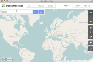
Routing on osm.org
Since February 2015, a navigation function (by car, by bike, on foot) has been available on [osm.org](https://www.openstreetmap.org/ ‘Routing on osm.org’)!
Have fun trying it out!
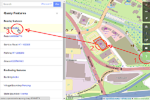
New "Query features" function
The OpenStreetMap website has a new “Query features” function:
Click on the question mark icon on the top right of the page Click on an object on the map Select the desired object from the list