We connect the community, organizations, authorities, companies, and everyone interested in OpenStreetMap. Together, we improve geodata and make it accessible to everyone.
Our Goal: To promote and enhance free geodata – together with you! Our Offering: We provide support for using OpenStreetMap, participating in the project, and answering questions about geodata. Our Role: As a bridge between the community and external partners, we foster dialogue and actively work on improving geodata quality.
General Information
Where is the Map?
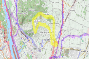
Here is an example map showcasing what can be done with OpenStreetMap:
I Want to Report an Issue!
You can report an issue directly on openstreetmap.org, or you can inform us at info@openstreetmap.at. We will get back to you as soon as our volunteer schedule allows – all our work is voluntary.
Find out how to support OpenStreetMap by visiting the Contribute page.
About the OpenStreetMap Project
OpenStreetMap (OSM) is an open, global database where geodata is collected by volunteers and made freely available. These data are the foundation for maps, navigation systems, and much more worldwide. Everyone can contribute – whether by adding a path, a park, or mapping entire neighborhoods in detail.
Learn more about OpenStreetMap on the About OSM page.
About OpenStreetMap Austria
History
OpenStreetMap Austria was founded in 2011 to organize the first “State of the Map” conference in Austria. Since then, we have built a rich history.
In 2023, following a community vote, we became the official Local Chapter for Austria.
Mission
OpenStreetMap Austria (OSM-AT) actively promotes OpenStreetMap activities in Austria. We assist in using OSM data, mediate between the community and external partners, and work to improve and expand geodata quality.
Our association acts as a voluntary point of contact for inquiries, clarifications, support, or mediation regarding OpenStreetMap.
We participate in various events, such as the Salzburg Maker Faire and the Graz Linux Days, to raise awareness about OpenStreetMap and strengthen the community. In the past, we were also present at the AGIT (formerly GI_Salzburg) and the Maker Faire Vienna, which unfortunately no longer take place.
Note on Data Sovereignty
OpenStreetMap Austria (OSM-AT) does not control the OpenStreetMap database and does not provide its own map material. We are also not responsible for the content of the database or the map.
The OpenStreetMap project is operated by a British NGO, the OpenStreetMap Foundation, which holds data sovereignty.
Since the planned FOSSGIS & OSM Community Meeting at the Linuxhotel Essen will not take place due to the current situation, the German FOSSGIS Association invites you to a virtual meeting on September 27, 2020starting at 1:30 p.m.. A joint virtual dinner is planned to start at 7:00 p.m. :-)
We have found a great replacement for the Vienna OSM meetups: We are going hiking!
On Sunday, August 23, 2020
starting point is the beginning of the city hiking trail 5 (Bisamberg route, https://www.wien.gv.at/umwelt/wald/freizeit/wandern/wege/wanderweg5.html) in Stammersdorf (terminal stop of the 31 tram line), where we will set off at 1:00 p.m. to follow the city hiking trail of the same name!
Due to the current pandemic, AGIT 2020 cannot be held locally. The organizers will hold it virtually instead!
OSGeo/FOSSGIS/OpenStreetMap have also received a sponsored virtual exhibition stand for the virtual conference! (Thank you, AGIT !)
Since it is hardly possible to have a virtual exhibition stand attended by volunteers for 5 days via video link (who have to go to work during the weekdays), we have come up with the following idea: