OpenStreetMap at Hochschwab.
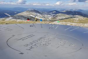
Since June 2016, anyone climbing the Hochschwab has been able to find a new panorama board there, which names the 40 peaks around the Hochschwab. OpenStreetMap data was used for the implementation and this is also wonderfully prominently displayed on the board!
A nice example of the inclusion of the required [copyright notice (attribution)] (https://www.openstreetmap.org/copyright) for non-digital products.